| Notes: |
| Marine coverage of all providers shown on this map for the Strait of Georgia was last verified between 11-17 November 2003; West Coast of Vancouver Island last verified late July 2004. |
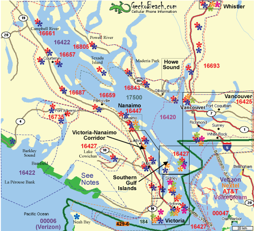
 | Dash polygons indicate approximate coverage areas of each provider: Blue=Telus CDMA, Red=Rogers AMPS/tdMA, Black=Bell CDMA, Orange=Telus Mike iDEN, Purple=Microcell GSM; Brown=Rogers GSM (under development, so some Red icons may also be GSM co-locations). Bell phones will roam on Telus outside Bell coverage areas. Coverage areas may vary somewhat between different equipment types, special antennae, or within buildings or ships. Coverage areas over water indicate marine coverage -- adjacent terrestrial coverage in these areas may be poor or non-existent. Not all cell sites are shown. |
| Telus Mobility users in the southwestern portion of Vancouver Island (Nitinat Lake, Carmanah Pacific, West Coast Trail) should note that they can roam on the Neah Bay Verizion tower. In mountainous areas find a high logging road before attempting a call -- your call may be placed through either the Neah Bay tower (Verizon SID 00006; CDMA PN 492)or the Mt. Ozzard tower. |
| A cellular phone is not an acceptable substitute for a marine VHF transceiver. Cellular phone users can reach the Coast Guard Rescue Coordination Centre by dialing *311 from your cellular phone (this number valid only in BC). Coast Guard can also be reached at *16. |
| Five digit numbers indicate System Identification Areas or SID's. Rogers uses unique SID's for their service areas and these are marked in red. Use these numbers to help determine which area tower your handset is accessing while in field debug or test mode.
Telus only uses one SID, 16422, to mark their service areas. If roaming on analog 'B' band, Verizon will show up as SID 00006; if roaming on analog 'A' band AT&T will show up as SID 00047. Roaming is usually indicated on handsets as a triangle or 'R'. Microcell's SID is 16420. |
| Juan de Fuca coverage area (Neah Bay to Victoria): Telus Mike has the best coverage along this route and usable signals can be obtained as far west as the entrance to Juan de Fuca Strait ("J-buoy").
Telus and Rogers users should also note that Verizon and AT&T signals are much stronger in this area and you may have to force your phone into Home Area only to prevent the incursion of roaming charges on American providers. |
| Barkley Sound, La Pérouse Bank, Bamfield, Tofino, Long Beach, Pacific Rim National Park, etc: Both Telus Mobility and Rogers have towers that serve these areas. Marine coverage of the Mt. Ozzard tower just northwest of Barkley Sound extends as far as 40 NM (75 Km) offshore with a 3W mobile phone; handhelds are limited to 30 NM (55 Km) from this tower; Telus' Autotel to 65 NM (120 Km). Rogers' SID for this area is 17051. Telus Mobility has better coverage north of Tofino due to an additional tower located near Hot Springs Cove (Rogers only has the one tower on Mt. Ozzard). Microcell customers may roam on Telus analog if they have a phone with an analog module. Bell Mobility customers may roam on Telus outside Bell Mobility coverage areas (which are not marked on this map). Telus Mike (iDEN) may be able to pick signals up from south of Neah Bay, although this has always been hit-and-miss on my tests. |
| Telus also offers CDMA coverage on Northwest Vancouver Island (primarily for marine traffic) -- see the Northern Vancouver Island map for coverage details. |
| Rogers calling area for Long Beach: Rogers customers in Tofino, Ucluelet, and Long Beach areas enjoy local calling to Port Alberni as these locations are all within their local calling area. |